BY
KRITI
KANAUJIA
Fig.1: Mapping unconventionally: Perceiving resemblance
Source: Heart world from www.facebook.com- Fb cartographical awww.... and South America shaped as Elephant’s trunk from Strange Maps 488 - Bodyworld: The Artography of Fernando Vicente by Frank Jacobs
The human life is conventionally dictated by norms, customs, values, traditions and so on that we collectively refer to as way of life or culture. Culture forms an integral, essential and significant part of human life as it provides us with a way to traverse our lives from birth till death and to manoeuvre through the obstacles presented and gifts rewarded throughout our lives.
Culture seems to map or
chart out our lifestyles, perception, relationships and even our world views.
But it is not a unidirectional process, rather a bi- directional vicious cycle,
wherein culture maps us and we define, redefine and even change the rules/ norms
by which culture dictates us. Changing times; change the way culture is mapped
and the way culture maps us and this brings us to the key attribute of
“Mapping”.
If we observe
throughout history, we have tried to map our existence in the form of pre-historic
cave art, rock cut forms/ sculptors, gigantic evidences (few examples may be
Nazca lines, Pyramids of Giza, ancient civilizations like Machu Pichu and so
on) mapping our existence throughout chorological (geographical) diversity.

Fig.
2: Mapping existence
Source:
earthobservatory.nasa.gov
Throughout history,
ancient till contemporary and ongoing, we map our existence in the form of
journals, memoirs, biographies, auto- biographies, passports, ownership
records, extensive social identity databases like Aadhar and even genealogical
records which map the relations and their descendents and so on. Genealogical
mapping transgresses races, cultures, history, geography and even time. But
mapping is not constrained till humanity rather is visible and practiced even
in the animal kingdom in the form of migratory routes, territorial limits,
water sources and even points and places providing shelter, security or danger.
Mapping is one thing or
practice which is performed intentionally or unintentionally for performance of
daily life. But we also map to
avoid disputes, settle inheritance, ownership on a more specialized basis
through the field of Cartography; which in present era has also dwelved into
GIS, Remote Sensing, Satellite Imagery and so on. Cartography has been as old
as mankind itself because we were required to map places for our efficient and
safe existence.
From the ancient Greeks
and Romans who mapped their descriptive knowledge of places as the Known World
to the Dark Ages when the world was confined and shaped into T in O to the Age
of Discovery which transformed large swathes of land from Terra Incognita to
Terra Cognita, cartography has traversed a lot of history and geography.

Fig.3: Mapped in Perception
Source: Europa: http://dabrownstein.wordpress.com/2013/04/, Fool’s head: "World Map Drawn in a Fool's Head." Ca.1590. Ptolemaic projection onto the face of a clown, taken from www.pinterest.com
At present, the world
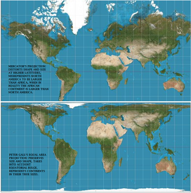
seems to be run and perceived by the lens of Mercator’s Projection[i]
dominating like a behemoth above its supposed minions (other projections like
Lambert Conical, Peter Gall’s Equal Area, Gnomonic, Dymaxion, Mollweide’s and
so on which are not so conventionally used to represent the world).
Fig.4:
A comparison between Mercator’s and Peter Gall’s grid based projection system.
Source:
Strebe: commons.wikimedia.org
Mercator’s projection
is considered to be a modern day norm and a supposed rule providing “the
realistic representation of earth on a flat surface”. It is a system based on
the intersection of parallels of latitude and meridians of longitude at 90
degree angles to provide every place on Earth a set of x, y co-ordinates for
ease of location and navigation. Mercator’s projection was made famous because
of its navigational ease used by Sailors and Sea farers back then. But it needs
to be brought to notice that this is not the only system of projection, nor is
it a modern day marvel. In ancient Rome and Greece, Ptolemy and Eratosthenes
have also prepared maps of the world on a grid system of latitudes and
longitudes.
Fig.5:
Ptolemy and Eratosthenes grid based projection system from ancient times.
Source: Ptolemy map: Ptolemaic maps by Girolamo
Porro,Venice, 1598, www.columbia.edu
and Eratosthenes map: pixgood.com
Even in Medieval times,
across large swathes of erstwhile Mughal Empire, the system of Land Records’
Keeping was maintained under a grid of latitudes and longitudes. The map
prepared was a very detailed “Masavi” map complete with its Index for
interpretation and was housed with the Land Records’ Office for safe keeping.
These Masavis were drawn every time at the time of Consolidation or Bandobast
with the year recorded at the top for later reference.
But this traditional
knowledge is being lost and over taken by modern day norms of mapping.
Toposheets, Satellite imageries, Aerial surveys and many other cartographic
techniques do provide visual mapping of the surface but they lack the micro
level knowledge of ground level realities. They lack the dynamic culture and
map only the static aspects of cultural manifestations.
The conventional
mapping does not take into account the mental maps we create on an everyday
basis or the fact that every map comes embedded with a map maker’s bias or
subjectivity. It is essential to have conventions for ease, comprehension by
the masses and passing down the knowledge to future generations but it should
not be at the cost of erasures, ignorance or obstructions in other types of
mapping. After all, unconventional maps are created, used and even transferred
to others on an everyday basis as they are essential for living and practicing
everyday lives and routines by the ordinary people.
In the present series, the contributors namely Kriti, Arunima, Nirdosh and Deepika, Ashutosh, Aparajita and Pooja are trying to shift focus to such (un)conventional themes and methods in which the world can be observed, mapped and the knowledge passed on to others in conventional yet interesting ways.
Kriti Kanaujia is currently pursuing her Doctorate in Philosophy from Department of Geography, Delhi School of Economics, University of Delhi. Her interest areas include urban planning and development, urban culture and society and urban aesthetics.
[i] Mercator’s Projection does not
preserve shape and size, it has a tendency to distort at the higher latitudes
thereby reflecting that North America is larger than Africa when in essence,
the contrary is the truth. Mercator’s also does not take into account the
Equatorial bulge hence distorting the shape and size of Countries, continents
near the Equator and reflecting them as small when in reality they may not be
so.
Mercator’s also has a bias of centering the world at
the Atlantic ocean when in reality, centering the world at the Pacific Ocean is
also a possible option and it also allows us to view the zig- zagging
International Date Line. There are serious repercussions for the world to be
viewed from the Mercator’s lens and an example may be the glaring perception of
north versus south.


Does your study of cultural cartographies of media also include virtual media (internet)?
ReplyDeleteyes, it does. we include a variety of themes...if you are interested in writing something on virtual media, please email us at medialalbtalks@gmail.com, for further information and queries..
DeleteQuite Interesting.
ReplyDeleteinteresting read, indeed! How our perception of the world is shaped, re-shaped and altered!
ReplyDelete